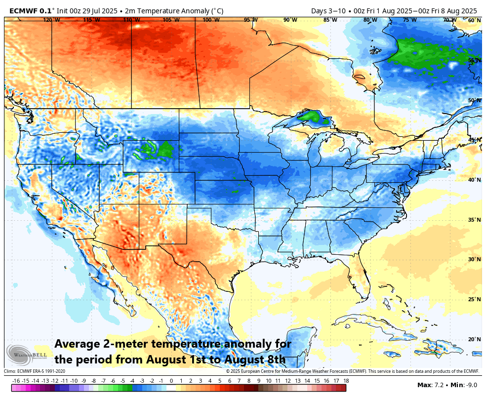
The month of August will get off to a colder-than-normal start across much of the nation (shown in blue). Map courtesy ECMWF, Weather Bell Analytics
Temperatures reached well up into the 90’s on Wednesday afternoon in much of the Mid-Atlantic region and Northeast US, but major-league relief is on the horizon…in fact, jackets may be required as we end the work week on Friday (and begin the month of August). A slow-moving cold frontal system – backed up by strong “Canadian-borne” high pressure – is pushing south and east today across the Great Lakes and will approach the Mid-Atlantic/Northeast US by later tonight. This frontal system will then get “hung up” on from Thursday into Thursday night in its advancement to the south and east as low pressure forms along its boundary zone. Numerous showers and thunderstorms are likely to develop on Thursday afternoon and night as the front grinds its way through the northeastern states and the rain can be heavy at times with localized flash flooding on the table.
On Friday, low pressure will slowly pull away from the east coast and there will be mostly cloudy skies and lingering showers in much of the I-95 corridor and especially along coastal sections from NJ to New England. In addition, the first day of the new month will feature well below-normal temperatures in this part of the country and a stiff east-to-northeast wind that will develop in a counter-clockwise fashion around the departing low pressure system. Clearing skies should develop by later Friday night and the weekend is likely to turn out to be one of the nicest of the entire summer season with comfortable temperatures and low humidity levels.
With the change in temperatures on the way for the Mid-Atlantic region and Northeast US, look for lower Home Run Forecast Index (HRFI) values for awhile in that part of the country. The HRFI has been very high in recent days – given the high heat and humidity – in such stadiums as Camden Yards in Baltimore and the ball has been flying…indeed, another “10” Index there for this afternoon’s game and another 4 HRs. Warmer-than-normal weather is likely to make a return to the northeastern states during the second week of August.
Meteorologist Paul Dorian