
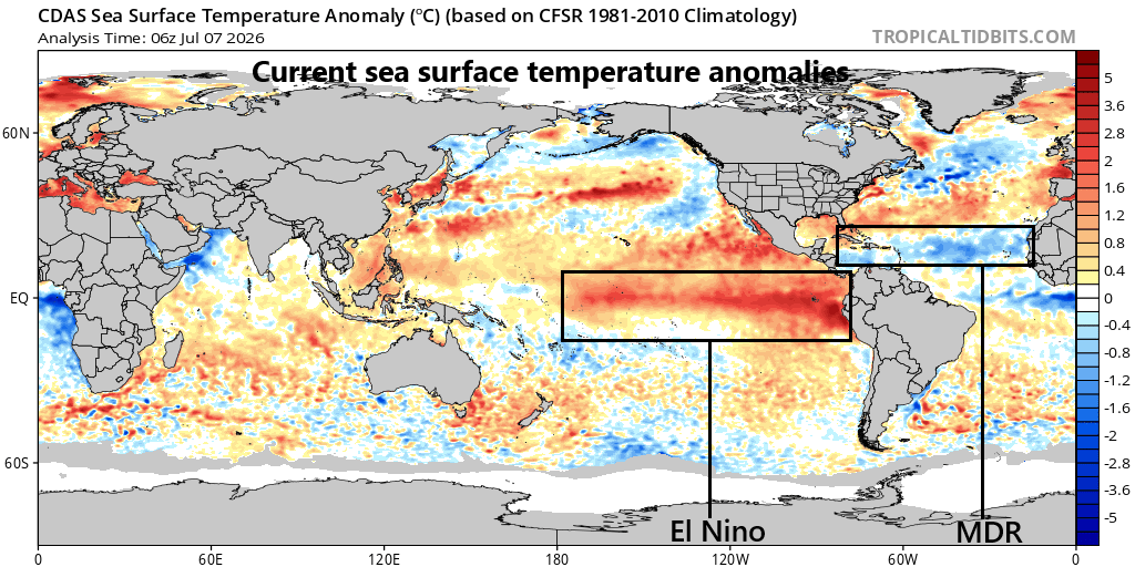
Warmer-than-normal water currently exists across the tropical Pacific Ocean with the development of El Nino with the eastern-most region near South America the warmest relative-to-normal. Map courtesy NOAA, tropicaltidbits.com
Overview
El Nino continues to intensify across most regions of the equatorial Pacific Ocean with well above-normal water temperatures that continue to rise rather sharply in recent weeks. In fact, all indications suggest that the overall magnitude of this unfolding El Nino will rival some of the great ones in recent history including those in 1982-1983, 1997-1998, and 2015-2016. The warmer-than-normal water across the Pacific Ocean is likely to lead to a very active next couple of months in terms of overall tropical activity and even the Hawaiian Islands may be impacted by a direct hit.
At the same time, colder-than-normal water currently exists across what is known as the “Main Development Region” of the Atlantic Ocean in terms of tropical activity, and this inhibiting factor combined with El Nino in the Pacific Ocean will likely lead to a quieter-than-normal season in the Atlantic Basin. Looking ahead, it appears El Nino will not only have an important impact on the near-term tropical seasons but potentially have a significant impact on the winter season of 2026.2027. Numerous computer forecast models suggest El Nino conditions will peak during the fall season and will last right into the early spring of 2027.
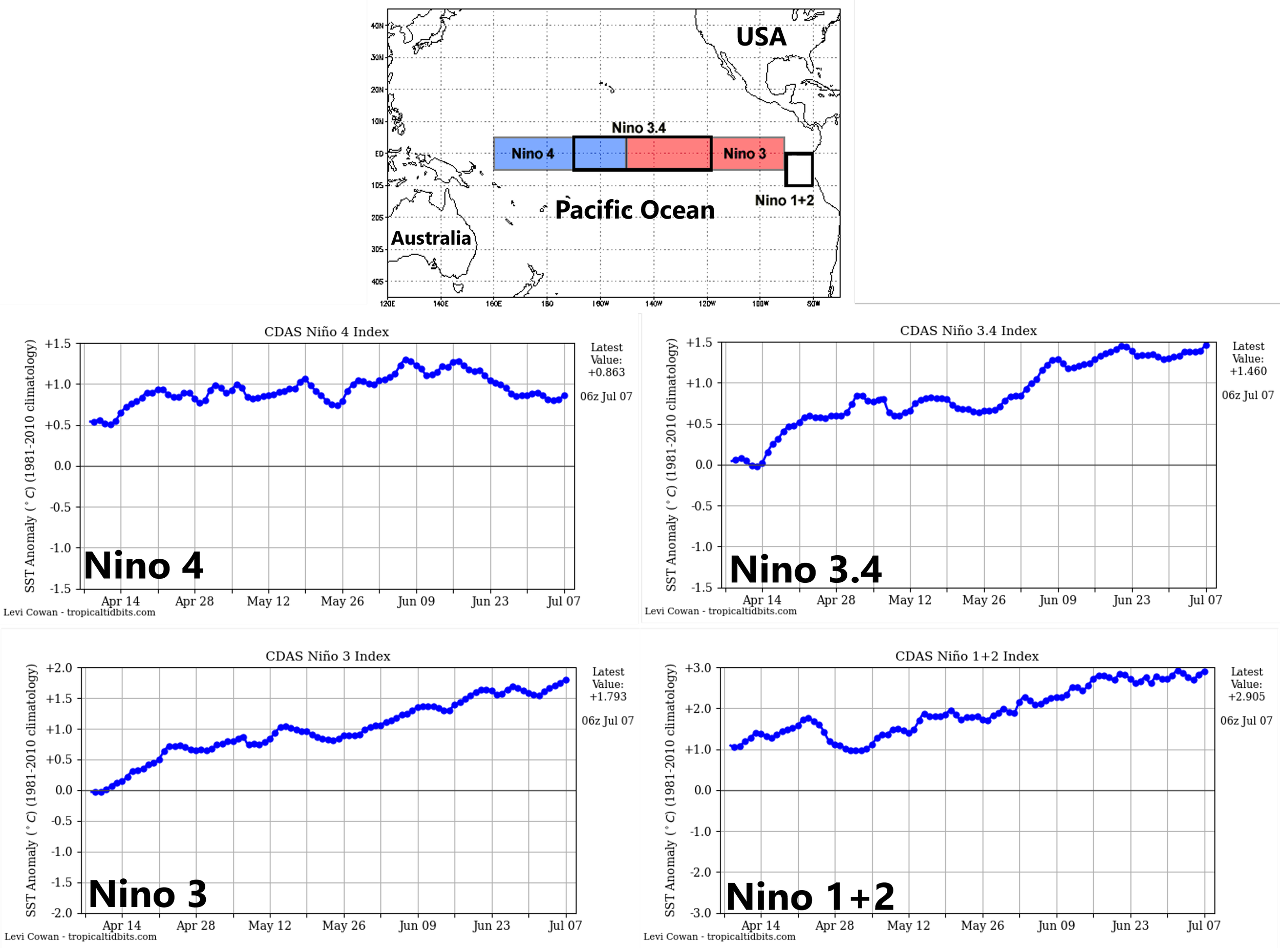
The El Nino region of the Pacific Ocean is divided into sub-sections by meteorologists as outlined on this map (top) with “Nino 3.4” region (5 °N-5°S, 120°W-170°W, boxed region in middle) in the central part of the equatorial Pacific Ocean and “Nino 1+2” (boxed region at right) positioned near the west coast of South America. Water temperatures have climbed dramatically in recent days across all four “regions” of the tropical Pacific Ocean as El Nino conditions become increasingly established. Plots courtesy NOAA, tropicaltidbits.com
The intensification of El Nino
Meteorologists separate the world’s largest ocean into four regions as a way of better pinpointing specific areas in the tropical Pacific and all are experiencing warmer-than-normal water temperatures. In fact, in all but the most westward region (Nino 4), water temperatures have been rising rather sharply in recent weeks. The warmest region relative-to-normal continues to be the far eastern region known as “1+2” that sits just off the west coast of South America and deep-sea buoys suggest this pattern may continue for at least a while longer.
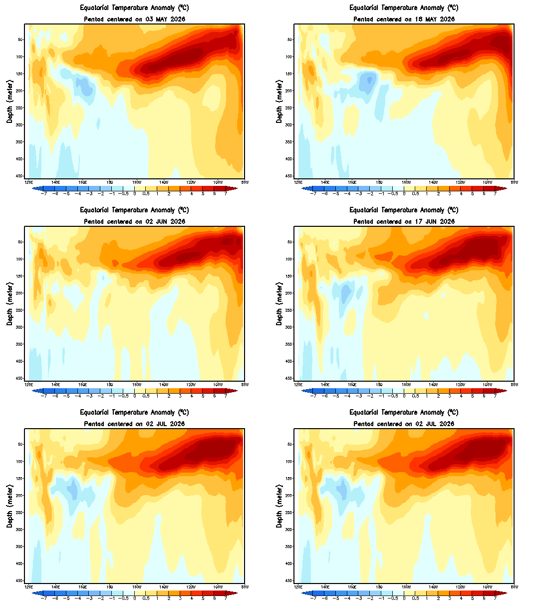
Sub-surface water temperature anomalies (°C) down to a depth of 450 meters are shown here from the equatorial part of the Pacific Ocean in the period from 03 May 2026 to 02 July 2026. Much warmer-than-normal water (shown in orange) is lurking just beneath the surface (top of map) across much of the eastern Pacific Ocean. Map courtesy NOAA/CPC, International Research Institute [Note – “Nino 3.4” region is 120°W-170°W.]
These instruments stationed in the tropical Pacific Ocean are measuring water temperatures that exist far beneath surface level. In fact, these instruments can capture water temperatures on a frequent basis all the way down to 450 meters beneath the surface and what they show is quite amazing. Water temperatures are running at significantly warmer-than-normal levels within the top 150 meters or so below the surface and this warm water is “bubbling” up to the top; primarily, in the eastern regions (Nino 3, Nino 1+2). The deep-sea buoys in the Pacific TAO (Tropical-Atmosphere Ocean) array operate as part of NOAA’s National Data Buoy Center and have undergone significant upgrades since the original array was completed in 1994. They provide critical “real-time” observations in the monitoring of El Nino (or La Nina) in the world’s largest ocean.
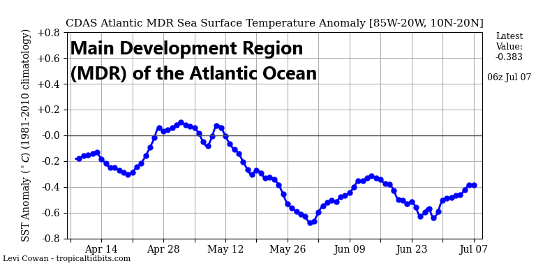
While the Pacific Ocean is featuring widespread warmer-than-normal water temperatures, the “Main Development Region” of the Atlantic Basin is cooler-than-normal as we head into the heart of the summer tropical season. Plot courtesy NOAA, tropicaltidbits.com
Impact on tropical seasons in the Atlantic and Pacific Basins
El Nino events in the past have had significant impacts on weather across many parts of the world and this one that can become especially strong will very likely be no exception. Significant impact by El Nino is not necessarily a bad thing. In fact, El Nino of this magnitude combined with cooler-than-normal water across the Main Development Region of the Atlantic Ocean will likely lead to an overall relatively quiet tropical season in the Atlantic Basin. El Nino is usually an inhibiting factor to the Atlantic Basin tropical season due to increased subsidence and wind shear (hostile conditions for tropical systems). Meanwhile, given the warmer-than-normal water across much of the equatorial Pacific (a favorable factor for tropical systems), the next couple of months could be very active with multiple powerful typhoons and even the Hawaiian Islands will have an increased chance this summer for a direct hit.
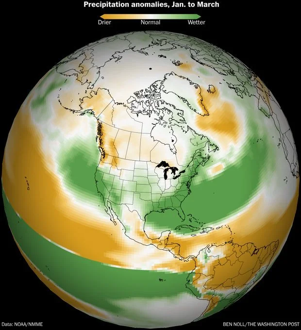
One typical impact of an “El Nino” winter is the activation of the southern branch of the jet stream which can lead to increased storminess (and precipitation) across the southern and eastern states. This is a forecast map of precipitation anomalies by NOAA’s North America Multi-Model Ensemble (NMME) for the January-March 2027 time period featuring that kind of wetter-than-normal pattern. Map courtesy NOAA (NMME), Washington Post (Ben Noll)
Potential impact on the 2026-2027 winter season
Signs point to a continuation of El Nino conditions as we head into the early part of 2027 which means there can be a big impact on next winter across the continental US. Some long-range forecast models indicate there can be an active southern branch of the jet stream next winter which could lead to more storms than normal in the southern and eastern states…not unlike prior El Nino events. One of the factors to monitor closely in coming months will be the most warming will take place relative-to-normal. An “east-based” El Nino with the warmest water relative-to-normal sitting just off the west coast of South America could overwhelm the US with mild Pacific air for next winter. However, a “central-based” event would open the door for some troughiness in the eastern US (and potentially some colder air compared to the “east=based” case). As discussed earlier, all near-term signals (e.g., deep-sea buoy observations) suggest an “east-based” El Nino event; however, there is still time for that to change before we get towards the latter part of the year.
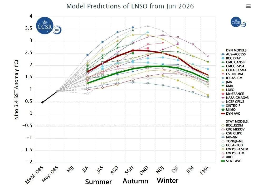
Forecasts of sea surface temperature (SST) anomalies are shown for the “Nino 3.4” region (5 °N-5°S, 120°W-170°W) of the tropical Pacific by a compilation of computer forecast models with general agreement on El Nino conditions after a brief period of “ENSO-neutral”. The computer models encompass two types – statistical and dynamic – with the average of each highlighted (red for dynamic, green for statistical). Plot courtesy NOAA, ECMWF, JMA, KMA, Canadian Met Centre, International Research Institute
An interesting note, the average of those three strong El Nino events in recent history (i.e., 1982-1983, 1997-1998, 2015-2016) produced much warmer-than-normal conditions in much of the country with the exception being the southwest US; however, there were also major east coast snowstorms (e.g., February 1983, January 2016).
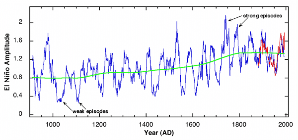
Using tree rings, rainfall and drought records, a reconstruction of El Nino events can be performed with some level of confidence going back hundreds of years. Some of the strongest El Nino events are believed to have taken place in the 17th and 18th centuries. (Source)
Historical context
As mentioned above, there have been three very strong El Nino events during the last 50 years with the most recent taking place in 2015-2016 and two prior in 1982-1983 and 1997-1998. El Nino and La Nina are the warm and cool phases of a natural climate pattern across the tropical Pacific known as the El Nino-Southern Oscillation or “ENSO” and we have evidence of this phenomenon going back hundreds of years using tree rings, rainfall and drought records. In fact, the El Nino event of 1877-1878 is often referred to as a “Mega or Super” event; especially impactful as it was in an era coming on the back end of the “Little Ice Age” and the preceding three years featured La Nina. It caused widespread drought, monsoon failure, and catastrophic famines across Asia, Africa, and South America, resulting in 19 to 50 million deaths.
Meteorologist Paul Dorian