
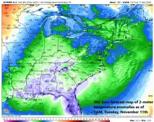
Arctic air will invade the eastern US early next week likely resulting in well below-normal temperatures all the way from Florida-to-Maine. Map courtesy ECMWF, Weather Bell Analytics
A strong cold front will head in a southeast direction on Sunday across the Great Lakes and it likely arrives in the northeastern states by Sunday evening. This cold frontal system will be at the leading edge of an Arctic air mass that originated near the North Pole and it will usher in the coldest air of the season so far to the eastern states. Surface low pressure will moves in a northeastward direction from the eastern Great Lakes to the southeastern part of Canada along the frontal boundary zone and there will be a very vigorous upper-level low providing support that dives south and east to the central Appalachians by early next week.
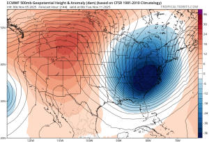
Vigorous low pressure aloft will play a big role in the instability (and snow) expected during this upcoming Arctic invasion. Map of Monday evening 500 mb height anomalies courtesy ECMWF, tropicaltidbits.com
The impact of this Arctic invasion will be widespread with temperatures well below-normal all the way from Florida-to-Maine on Monday and Tuesday. In addition, accumulating snow is likely in numerous places including the Great Lakes region, interior sections of the Mid-Atlantic, Northeast US, and New England. And given the instability expected associated with the powerful upper-level low, snow showers may be possible all the way into the I-95 corridor region during the early part of next week.
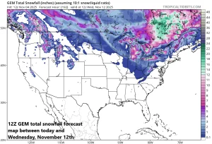
The Great Lakes “snow machine” may get turned on early next week with the arrival of Arctic air on top of some still relatively warm lake waters. Snow is also a possibility across interior sections of the Northeast and New England and could extend down to the Appalachian Mountains into the Tennessee Valley and even the I-95 corridor might see some snow shower activity. Map courtesy Canadian Met Centre, tropicaltidbits.com
Meteorologist Paul Dorian