
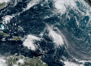
Hurricane Gabrielle can be seen at the top portion of this satellite imagery loop…another tropical system is visible over the northeastern Caribbean Sea, and a third is positioned not far off to its east. Images courtesy NOAA/GOES-East
The Atlantic Basin is quite active as we head towards the end of September with three tropical systems currently on the playing field including a “major” Hurricane Gabrielle which is now racing off to the east-northeast and is no threat to the US. In fact, Hurricane Gabrielle could impact the Azores Islands and Portugal down the road in a weakened state after crossing over the cooler waters of the North Atlantic.
Meanwhile, the other two tropical systems pose more of a challenge in terms of forecasting their eventual paths and magnitudes. It appears quite likely that both systems will reach named tropical storm classification and potentially, both may climb to hurricane status. It also appears quite likely that these two systems will end up doing some sort of a dance around each other for awhile (“Fujiwhara effect”) and at least one may come uncomfortably close to the US east coast and we may not know the end of the story until we get ten or so days out from now.
Meteorologist Paul Dorian