Wednesday, July 8th, 2026 – *El Nino continues to intensify in most regions of the tropical Pacific…big implications on Pacific and Atlantic tropical seasons…likely impact on upcoming winter season*
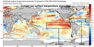
Warmer-than-normal water currently exists across the tropical Pacific Ocean with the development of El Nino with the eastern-most region near South America the warmest relative-to-normal. Map courtesy NOAA, tropicaltidbits.com Overview El Nino continues to intensify across most regions of the equatorial Pacific Ocean with well above-normal water temperatures that continue to rise rather sharply […]

June 6th, 2026 – *The most important weather forecast of all-time for the D-Day invasion…82 years ago…now a new movie on the intense pressure leading up to June 6th, 1944*
The American Cemetery in Normandy France is located on a bluff high above the coast and these hallowed grounds preserve the remains of nearly 9,400 Americans who died during the Allied liberation of France. Within the picturesque trees, an immense array of headstones rises in long regular rows and the buried include forty-five sets […]
Thursday, April 23rd – *The development of El Nino and the atmospheric response…an increase in severe weather outbreaks…an increase in rain events*
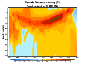
Sub-surface water temperature anomalies (°C) down to a depth of 450 meters are shown here from the equatorial part of the Pacific Ocean in the period from 17 February 2026 to 18 April 2026. Much warmer-than-normal water (shown in orange/brown) is now lurking just beneath the surface (top) across much of the tropical Pacific and […]
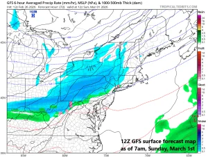
Monday, March 23rd – *Approaching strong cold front to play a role on Opening Day, Thursday, March 26th*
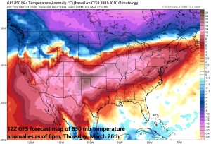
A strong cold front will be at the leading edge of a colder-than-normal air mass on Thursday. This front will approach the Mid-Atlantic and Midwest later Thursday which is Opening Day for several teams in this part of the nation. Map courtesy NOAA, tropicaltidbits.com The 2026 season gets underway with one game on Wednesday night […]
Saturday, March 14th – *An intense storm system will have an impact across a large part of the nation…ranging from blizzard conditions to severe weather*
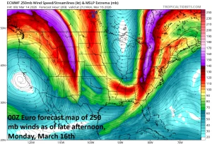
A vigorous upper-level jet will enhance upward motion later Monday in the Mid-Atlantic region leading to the chance for severe weather and this will include a risk of tornadic activity. Map courtesy ECMWF, tropicaltidbits.com Overview An intense storm system will develop later this weekend, and it will have an impact over a large part […]
Friday February 27th, 2026 – *Arctic front arrives on Sunday in the Mid-Atlantic…much colder early next week with some wintry precipitation…big-time warmup late next week/weekend*
A strong Arctic cold front arrives in the Mid-Atlantic region on Sunday and it may be accompanied by snow shower activity; especially, in areas to the north of the PA/MD border. After a very mild Saturday, temperatures will begin to trend downward on Sunday, and by the time Monday rolls around, Arctic air […]
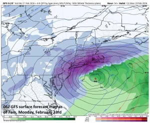
Saturday, February 21st – *Major winter storm to slam much of the Mid-Atlantic region from Sunday into Monday…all-out blizzard conditions in some areas*
Strong support in the upper atmosphere will lead to rapid intensification of a storm system just off the Mid-Atlantic coastline from later tomorrow into tomorrow night. Map courtesy NOAA, tropicaltidbits.com Overview Major winter storm to slam much of the Mid-Atlantic region… All-out blizzard conditions in some areas… Low pressure will intensify rapidly later tomorrow […]
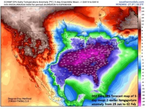
*Memorable stretch of cold in terms of both magnitude and duration in the Mid-Atlantic region…near 0 degrees for overnight lows on multiple occasions…potential coastal storm this upcoming weekend*
The 5-day period from 29 January to 02 February looks to be especially cold in much of the eastern US and this includes the central and southern portions of Florida. Map courtesy ECMWF, weathermodels.com (Dr. Ryan Maue, X) Overview In the wake of the major weekend winter storm, a very cold weather pattern is […]
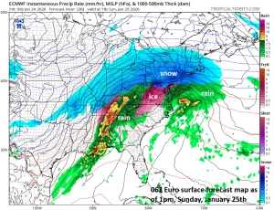
*Major winter storm arrives tonight in the Mid-Atlantic region with disruptions into Monday…significant snow and significant icing in the I-95 corridor…bitter cold to follow*
Snow should be falling heavily on Sunday morning in much of the DC-to-Philly-to-NYC corridor with very cold conditions…some wild weather indeed for several hours. There can be sleet and freezing rain across central and western Virginia by mid-day as a thin layer of slightly above freezing air advances slowly to the north with its farthest […]
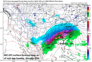
*Major winter storm to impact the DC-to-Philly-to-NYC corridor from later Saturday night into Monday…significant snow accumulations and some icing…bitter cold to follow*
Snow should be falling heavily on Sunday morning/mid-day in the DC-to-Philly-to-NYC corridor with very cold conditions…some wild weather indeed for several hours. There can be sleet across central and southern Virginia at mid-day and freezing rain in Kentucky as a thin layer of slightly above freezing air advances slowly to the north with its farthest […]