
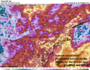
Total precipitation amounts over the next ten days as depicted by the 00Z Euro. Map courtesy ECMWF, Pivotal Weather
Overview
Lawns were turning brown and soil moisture was at very low levels earlier this month and during the month of May in much of the Mid-Atlantic region. There have been a couple of rain events in the past couple of weeks that have alleviated the dry conditions; especially, in areas to the north of the PA/MD border. The overall weather pattern is now evolving into one that will bring copious amounts of rainfall to the Mid-Atlantic region in coming days and it may get to the point in which many will say “we’re now getting too much of a good thing”. In addition, this wetter weather pattern will most likely result in some postponements in coming days for MLB. In terms of temperatures, a cool June so far in the Mid-Atlantic has suppressed the Home Run Forecast Index (HRFI) and this type of pattern will continue in the short-term.
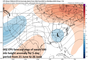
An upper-level trough of low pressure will keep it unsettled in the Mid-Atlantic region during the next five days. Map courtesy NOAA, tropicaltidbits.com
Details
It has been a wet and unseasonably cool day on Wednesday from the DC metro region to the Delmarva Peninsula and an easterly flow of air has become quite gusty given the combination of high pressure to the north and low pressure to the south. This rain shield has been slowly advancing to the north in recent hours and the southern part of Pennsylvania is getting in on some of the action this afternoon.
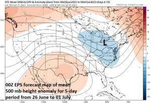
A second upper-level trough of low pressure will keep it unsettled in the Mid-Atlantic region later next week. Map courtesy NOAA, tropicaltidbits.com
Today’s rainfall in the Mid-Atlantic region is not going to be an aberration as it look like there will be a daily threat of showers and thunderstorms from today into at least the early part of next week. In fact, it very well could stay on the wet side right into the month of July and tropical moisture may very well get involved in the overall pattern by later this summer.
In the near-term, an upper-level trough will edge its way northward from the Tennessee Valley to a position over the Mid-Atlantic region by later this weekend. Beyond that, it appears that a follow-up upper-level trough will slide to the south and east from the Upper Midwest to the Mid-Atlantic region by later next week keeping it unsettled around here.
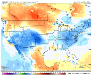
Much of the US has been cooler-than-normal in the month of June so far including in the Mid-Atlantic region where the Home Run Forecast Index (HRFI) has been rather suppressed. Map courtesy Weather Bell Analytics, NOAA
In terms of temperatures, the persistent east-to-northeast flow that has formed between high pressure to the north and low pressure to the south has brought cooler (ocean) air westward from the western Atlantic Ocean. On this first day of the summer season, mid-day temperatures were generally in the 60’s along the I-95 corridor and they’ll stay well below-normal on Thursday as well with a continuation of the east-to-northeast flow and the continuing threat of showers and thunderstorms. The average high temperature today ranges from 83 degrees in Central Park, NY to 85 degrees in Philly to about 87 degrees in the DC metro region. This cool weather is keeping the HRFI on the low side for this time of year and that will continue in the short-term. As an example, the HRFI for the Yankees game on Wednesday evening in New York City is quite an amazing 1…all on the 1st day of summer.
On Friday, the high pressure system to the north will shift to a position off the east coast and this will cause a change in low-level wind flow to more of a southerly direction instead of easterly. As a result, temperatures should bounce back to near 80 degrees for Friday afternoon highs and then to well up in the 80’s this weekend.
Meteorologist Paul Dorian