
Overview
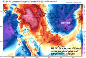
A couple of cold fronts will usher in a spectacular air mass for this time of year to the Mid-Atlantic/Northeast US/Great Lakes just in time for the upcoming Father’s Day weekend. Strong high pressure will take control of the weather for the weekend in the northeastern part of the nation…a system that had its origins up in northern Canada. Elsewhere, intense heat will continue to affect the region from the south-central states-to-the Midwest-to-the Southeast US over the next couple of days and then relax a bit this weekend and then come back in full force during the first half of next week. Some of this hot air will try to make it into the Mid-Atlantic region by the middle of next week.
Details
The Mid-Atlantic region has enjoyed several comfortable air masses this spring season, but many of them have arrived during the work week. The next comfortable air mass coming to this area looks like it will be perfectly timed with the likelihood for a great stretch of weather from Saturday into Monday. Following the passage of the secondary cold front, a very comfortable air mass will pour into the northeastern quadrant of the nation for the weekend riding in on stiff N-NW winds. High pressure which had its origins way up in northern Canada will be the anchor for this comfortable air mass both on Saturday and Sunday and even into the day on Monday. Temperatures in the Mid-Atlantic region will largely hold in the 70’s by day along with plenty of sunshine and then drop to the cool 50’s at night. Humidity levels will be low for this time of year with very comfortable dew point readings.
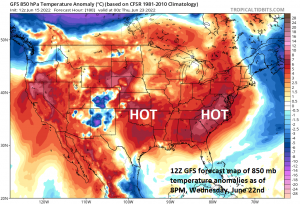
Meanwhile, very hot weather continues to dominate the scene from the south-central US to the southeastern states as strong high pressure ridging persists in the upper part of the atmosphere. Many spots will come close to triple digit highs over the next couple of days including, for example, Atlanta, Georgia and the intense heat will relax a bit this weekend and then reassert itself early next week. Some of this hot air mass will try to make an advance to the north and east early next week and this puts a significant warm-up on the table for places like Washington, D.C. by next Tuesday or Wednesday.
Impact on Home Run Forecast Index (HRFI)
The upcoming weather pattern across the nation will have dramatically different impacts on the Home Run Forecast Index (HRFI) and on the ability of the baseball to travel. In the Great Lakes/Mid-Atlantic/Northeast US, the combination of colder-than-normal temperatures and low humidity values this weekend will suppress the HRFI to low or moderate levels and will likely be unfavorable for baseballs to travel. This could impact the games in such baseball towns as Pittsburgh, Baltimore, Washington, D.C., Boston and New York (Mets).
On the other hand, the intense heat expected in the central US, much of the Midwest, and the Southeast US during the first half of next week will result in high index values and quite favorable conditions for baseballs to travel. This could impact big-league games played next week in Houston and Arlington in Texas (if their roofs are open), St. Louis, Kansas City, Chicago, Cincinnati and Atlanta.
Meteorologist Paul Dorian